The SBBC+ is proud to be involved in the following projects that are aligned with our mission. Select a project below to learn more about what we are doing. As always, we welcome volunteers to participate.
South Bay Current and Proposed Bicycle Infrastructure Project
StoryMap
Take some time to scroll through this StoryMap which catalogs the current and proposed bicycle infrastructure in the South Bay and additionally provides context with regards to collision data and other regional bike plans. This is intended to be a policy tool to help guide decision-making towards building out a network of safe and connected bicycle infrastructure.
The South Bay Bicycle Master Plan is updated to call for protected bike lanes (Class IV) in lieu of Class 2 for a majority of routes, as reflected in the map. This aligns with guidance from Caltrans and other regional plans from LA County and LA Metro. See the StoryMap for more details.
Navigating the interactive map
The map presented in the above StoryMap can be explored in further detail here .
To add any suggestions, ideas, or feedback:
Click “Edit” in the sidebar
Click “New Feature”
Drop a point wherever you’d like on the map
Fill out the form and click “Create” to log your point.
Click the “Layers” tab to turn on/off the visibility of different data
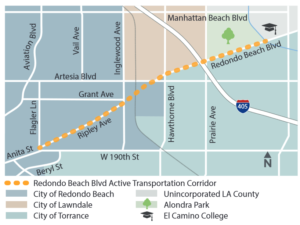
Redondo Beach Blvd Transportation Corridor Metro Project

The Redondo Beach Blvd Active Transportation Corridor Metro Project
ATTENTION 12/1/2022- We need your input to prioritize improvements on Redondo Beach Blvd. Take a short survey before December 31, 2022 and get automatically entered into a raffle for a free bike or a $200 gift card. :
A 3.3 mile bicycle and pedestrian facility between Redondo Beach Blvd/Ripley Ave from Flagler Lane on the west to the Dominguez Channel Greenway on the east.
The South Bay Bicycle Coalition Plus (SBBC+) is proud to announce that it has been selected by Metro as its Community Based Organizer (CBO) for a project to install new bicycle and pedestrian facilities between Redondo Beach Blvd/Ripley Ave from Flagler Lane on the west to the Dominguez Channel Greenway on the east for a total of 3.3 miles. Over the next year SBBC+ will be helping Metro complete the Planning and Design phase by hosting events throughout the South Bay to educate residents about the project and collect feedback. The goal of this effort is to ensure the final project plan reflects the active transportation needs and desires of the South Bay. Other vital partners of this project include the Los Angeles County Department of Public Works, Cities of Redondo Beach, Lawndale, and Street Racing Kills.
SBBC+ intends to connect with as many South Bay residents as possible by hosting information booths at community events throughout the year and widely promoting those events through social media, email and newspaper ads.
Schuyler Heim Bridge Bikeway Project
The SBBC+ has been selected to participate on a Caltrans team to establish a bikeway connector from Long Beach to the Southy Bay; as part of the Pacific Coast Bike Route; Mexico to Canada.
South Bay Area Bicycle and Pedestrian Collision Data, 2018-2022
Below are individual collision data report cards for selected South Bay cities, highlighting trends in collisions for both cyclists and pedestrians from 2018-2022. The data is queried from the SWITRS (Statewide Integrated Traffic Records System) database using the TIMS (Transportation Injury Mapping System) website from UC Berkeley. This can also be explored in finer detail by making a free account at tims.berkeley.edu to browse the map.
Feel free to Contact Us if you have any questions or would like to discuss the data and/or what can be done to improve safety in our community.
(NOTE: Each report opens in a new tab)
